
Cotopaxi is the volcano on every Ecuador postcard: a nearly perfect snowcapped cone rising above windswept grasslands. Only a couple of hours from Quito, it is one of the easiest places in the Andes to get close to a glacier without being a mountaineer. A day trip lets you walk around a high lagoon, hike to a mountain refuge and ride a bike down the slopes. This guide explains how to plan your visit and what to expect at altitude.
Cotopaxi at a Glance
Cotopaxi reaches about 5,897 m a.s.l., making it one of the highest active volcanoes in the world. The national park that surrounds it was created in 1975 and protects páramo grasslands, lagoons and the volcano’s glaciers. On clear days, you can also see Rumiñahui, Sincholagua and other peaks from inside the park.
An active volcano under constant watch
Cotopaxi has erupted many times in recorded history, and it has shown renewed activity in recent years, with periods of ash emissions. It is monitored continuously, and access to certain areas, especially the refuge and the summit, can be restricted depending on its activity. Check the current status before your visit.

Driving from Quito to the Park
The Pan-American Highway and the Avenue of the Volcanoes
The park lies about 50 to 60 km south of Quito, and the drive takes around one and a half to two hours. The route follows the Pan-American Highway through the valley known as the Avenue of the Volcanoes, named by the explorer Alexander von Humboldt for the line of peaks along both sides.
Park entrances and checkpoints
The main entrance is reached from the highway near Lasso, where a checkpoint registers visitors. A dirt road then climbs through pine forest and open páramo toward the lagoon and the parking area below the refuge. Another entrance on the north side is less used and better suited for longer tours or overnight stays.
Limpiopungo Lagoon Loop
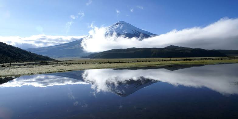
Limpiopungo is a shallow lagoon at around 3,800 m a.s.l., with Rumiñahui on one side and Cotopaxi on the other. A flat trail of about 2.5 km circles part of the lagoon, making it a good way to adjust to the altitude before hiking higher. Look for Andean gulls, ducks and wading birds along the shore.
Hiking to the José Rivas Refuge
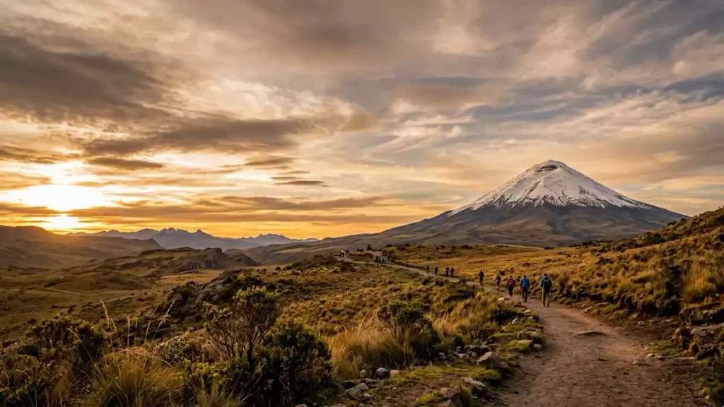
From the lagoon, the road continues to a parking area at around 4,500 m a.s.l. From there, a steep trail of loose volcanic sand climbs to the José Rivas refuge, at about 4,860 m a.s.l. The distance is short, but the altitude and the soft ground make it demanding, and most people take between 45 minutes and an hour.
The final push to the glacier edge
When conditions allow, a trail continues from the refuge to the edge of the glacier, at roughly 5,000 m a.s.l. Standing next to the ice with the valley below is the highlight of the trip for many visitors. The extra climb takes around 30 to 45 minutes more.
Signs you should turn back
If you experience a strong headache, nausea, dizziness or unusual shortness of breath, stop and descend. Weather can also change quickly, and strong wind or snow is a good reason to end the hike at the refuge.
Riding Down by Mountain Bike
Many tours offer the option of riding a mountain bike from the parking lot down to the lagoon or beyond. The route is mostly downhill on a dirt road, with views of the volcano behind you. It is a fun way to descend after the hike, though the road can be bumpy, so good brakes and a helmet are essential.
Páramo Wildlife and Plants
The páramo is a high-altitude grassland ecosystem found in the northern Andes. In Cotopaxi you may see wild horses, white-tailed deer, Andean foxes and, with luck, the Andean condor. Look for the orange chuquiragua flower, known as the flower of the mountaineers, and the cushion plants that store water and help regulate the ecosystem.
Horseback Riding with the Chagras
The haciendas around Cotopaxi are home to the chagras, Ecuador’s Andean cowboys, who still work cattle on horseback. Several haciendas offer riding trips across the páramo, from short rides to full-day excursions with views of the volcano. It is a quieter alternative to the refuge hike and gives you a sense of rural life in the highlands.
Climbing the Summit: What It Takes
Reaching the summit of Cotopaxi is a serious mountaineering objective. Climbers usually spend at least a week acclimatizing, including hikes on lower peaks. The climb starts around midnight from the refuge, requires crampons, ice axes and ropes, and must be done with a licensed mountain guide. It is only possible when the volcano’s activity allows.
Staying Overnight at a Hacienda
Spending a night near the park gives you a better chance of seeing the volcano at sunrise, when the sky is often clear. Historic haciendas in the area offer fireplaces, traditional food and horseback riding. Some are old colonial estates that still work as farms.
Clear Skies and Cloud Cover
Cotopaxi is often hidden by clouds, so it helps to go early in the day. The driest and clearest months are usually from June to September, although strong winds are common during that period. December and January can also bring good views. Weather in the páramo changes quickly in any season, so a clear morning can turn into fog within an hour.
What to Wear on a Cold, Windy Volcano
Temperatures near the refuge can drop below freezing, and the wind makes it feel colder. Wear thermal layers, a warm jacket, a waterproof shell, gloves and a hat. Sunglasses and sunscreen are essential, as the sun at this altitude is very strong even on cloudy days. Hiking boots help on the loose sand.
Other Volcano Excursions from Quito
If you enjoy Cotopaxi, other day trips from Quito include the Quilotoa crater lake, farther south, and the TelefériQo cable car, which climbs the slopes of Pichincha above the city. You can combine these with city visits and plan the rest of your stay using our guide to plan your trip to Quito.
Fitting Cotopaxi into a Multi-Country Trip
Cotopaxi fits well after a few days in Quito, once you have adjusted to the altitude. It can also be a stop on the way south to Baños or Cuenca. If you want Ecuador as part of a broader route, our tour covering South America in 12 days combines several destinations in one trip.
Frequently Asked Questions
Do I need a guide to visit Cotopaxi National Park?
For the lagoon and viewpoints, many visitors go with a tour. For the summit climb, a licensed mountain guide is required.
Is there an entrance fee for Cotopaxi?
Entrance to Ecuador’s mainland national parks has generally been free, but conditions can change. Confirm before your visit.
How early should I leave Quito?
Leaving around 7:00 a.m. gives you the best chance of clear views and time to hike before the afternoon clouds.
Can I visit Cotopaxi with children?
Yes. The lagoon loop and viewpoints are suitable for children, while the refuge hike is better for older kids who are used to altitude.
Is the refuge hike harder than it looks?
Yes. The trail is short, but loose sand and the altitude make every step tiring. Walk slowly and rest often.
Can I combine Cotopaxi and Quilotoa in one day?
It is possible, but it makes for a very long day with many hours in the car. Two separate days, or an overnight stay nearby, is more enjoyable.